Daughters of the American Revolution
The National Society of the Daughters of the American Revolution (NSDAR or DAR) is a service organization open to any woman age 18 years and older who can prove lineal descent from an American Revolutionary War Patriot. Much of the work of DAR is accomplished by volunteers in its chapters across the United States and internationally in order to promote historic preservation, education, and patriotism.
The Four Peaks Chapter, NSDAR, is based in Fountain Hills, Arizona, and our members come from many parts of the area and beyond.
Contact us to learn more about joining the DAR and the Four Peaks Chapter, NSDAR.
Our Chapter
In keeping with the purpose of the National Society, chapter members work together on numerous projects in order to promote historic preservation, education, and patriotism. We all have busy lives, so our projects offer ways to contribute that fit our schedules. We keep in touch across our many service projects through monthly meetings, where we enjoy an informative program, a business session, and socializing. Learn more about our activities.
We invite you to contact our chapter registrar who will help you get started in becoming a member of DAR, including tracing your heritage to find an American Revolutionary War Patriot.
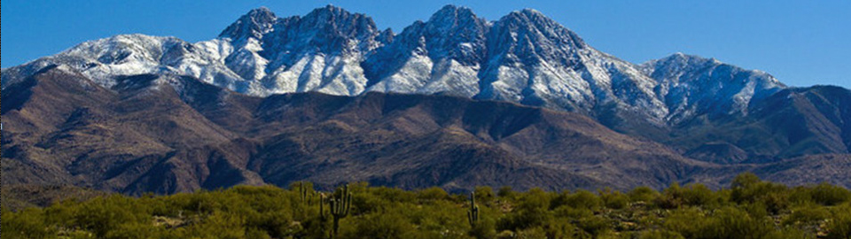
Chapter Namesake
Our name represents a range of mountains that forms a backdrop for the communities of Fountain Hills and Rio Verde and is considered sacred by the Yavapai community of Fort McDowell. The Four Peaks area comprises the southern portion of the Mazatzal Mountains, an extensive range that forms the western boundary of the famous Tonto Basin. Always an important landmark in this part of Arizona, and reaching nearly 8,000 feet, they dominate our skyline
Request Membership Information
Website last updated: September 27, 2024
The content contained herein does not necessarily represent the position of the NSDAR. Hyperlinks to other sites are not the responsibility of the NSDAR, the state organizations or individual DAR chapters.
Image courtesy of a chapter member.